Friday, March 13, 2015

Haeska

Geodashing Dashpoint Log
2015-03-13 22:01:44 UTC
GDCN-MOUN

Player: Haraldpoiss
Team:   FinEst Dashers

GDCN-MOUN is near Kõljala, Estonia.

> Date, Points, TeamPoints, Dashpoint, Country, State, Lat, Lon, Distance
2015-03-01, 3, 3, GDCN-MOUN, Estonia, , 58.4369, 22.6499, 0

Number of previous hunts by Haraldpoiss: 67

Bus dropped me 2km from the point, from where I took a walk. Weather was couple of degrees above 0C, cloudy and little bit windy. The point was on the edge of a meadow, next to a compost pile. After that I took a long walk in nature, because the next bus back was 6h later ;)  It was nice and relaxing like always.

http://geodashing.gpsgames.org/cgi-bin/dp.pl?dp=GDCN-MOUN


Birch catkins - spring is coming...

First time for me to see a solar powered electric fence. Very cool. The word on the sign means "horse".


Saturday, February 21, 2015

Võiküla

Geodashing Dashpoint Log
2015-02-15 19:33:39 UTC
GDCM-MUOT

Player: Haraldpoiss
Team:   FinEst Dashers

GDCM-MUOT is near Hellamaa, Estonia.

> Date, Points, TeamPoints, Dashpoint, Country, State, Lat, Lon, Distance
2015-02-01, 3, 3, GDCM-MUOT, Estonia, , 58.5464, 23.3733, 0

Number of previous hunts by Haraldpoiss: 66

It was a cloudy winter day with temperature around 0C. The road to the dashpoint started from Kuivastu harbor. It's the famous paved road to the village named Võiküla, which would mean 'Butter Village' in English. The road was built by the last Emperor of Russia, Nicholas II, in the beginning of 20th century to access the powerful cannon battery on the coast. It's 3km from the harbor to the village and one more km from there to the west to the dashpoint. As you can imagine, this old road is not especially car-friendly, but luckily there was some snow on it, which made it little bit smoother. Beside the road there was a big transformer station, which i checked from behind the fence. There was also a 50m high tower next to it, but i decided to not climb it, because underneath it there was a booth that had a sign on the door saying that there is an alarm system inside. The point was in woods, near the edge of a meadow. After visiting it, I took a walk on coastal plains towards Võilaid (The Butter Islet).

http://geodashing.gpsgames.org/cgi-bin/dp.pl?dp=GDCM-MUOT


Entrance only for short people :P

Butter village

ice conditions

Asuka

Geodashing Dashpoint Log
2015-01-30 21:37:43 UTC
GDCL-MOOT

Player: Haraldpoiss
Team:   FinEst Dashers

GDCL-MOOT is near Olga, Estonia.

> Date, Points, TeamPoints, Dashpoint, Country, State, Lat, Lon, Distance
2015-01-11, 3, 3, GDCL-MOOT, Estonia, , 58.5810, 22.4710, 35

Number of previous hunts by Haraldpoiss: 65

It was a dull winter day. There was a lot of snow on the roads, so I went side ahead quite many times while driving :)  I parked about 400m from the point and walked from there along the coastline. It was quite windy out there and the waves were big and powerful (for Baltic sea). The point appeared to be in water, 35m from the shore.

http://geodashing.gpsgames.org/cgi-bin/dp.pl?dp=GDCL-MOOT


Tupenurme

Geodashing Dashpoint Log
2015-01-11 20:01:00 UTC
GDCL-MUKU

Player: Haraldpoiss
Team:   FinEst Dashers

GDCL-MUKU is near Kapi, Estonia.

> Date, Points, TeamPoints, Dashpoint, Country, State, Lat, Lon, Distance
2015-01-04, 3, 3, GDCL-MUKU, Estonia, , 58.6617, 23.2034, 0

Number of previous hunts by Haraldpoiss: 64

It was a windy winter day with occasional snowfall. There was a lot of snow on the smaller country roads, but still it was possible to drive to 700m from the point. From there we walked along the edge of a meadow and reached easily to the destination. Afterwards we did some geocaching on the beautiful northern coastline of island Muhu.

http://geodashing.gpsgames.org/cgi-bin/dp.pl?dp=GDCL-MUKU


a lonely tower


Friday, January 9, 2015

Suure-Rootsi 2

Geodashing Dashpoint Log
2014-12-31 15:41:01 UTC
GDCK-MOSA

Player: Haraldpoiss
Team:   FinEst Dashers

GDCK-MOSA is near Pihtla, Estonia.

> Date, Points, TeamPoints, Dashpoint, Country, State, Lat, Lon, Distance
2014-12-31, 3, 3, GDCK-MOSA, Estonia, , 58.2170, 22.7059, 0

Number of previous hunts by Haraldpoiss: 63

It's the last day of year 2014 and we decided to visit the 2nd dashpoint of
December on Saaremaa island just before sunset. The weather was around 0
degrees Celsius and roads were very slippery. At 1.1km before the dashpoint we
had to stop because of "private road" sign, from where we walked onward. We
passed by a shelter with video surveillance and there were some bulls outside
on the pasture. The point was on a snow-covered coastal meadow between
junipers.

http://geodashing.gpsgames.org/cgi-bin/dp.pl?dp=GDCK-MOSA


Eskimos...

Sunday, December 28, 2014

Innermanzing

Geodashing Dashpoint Log
2014-12-28 15:57:22 UTC
GDCK-LANY

Player: Haraldpoiss
Team:   FinEst Dashers

GDCK-LANY is near Neustift Bei Altlengbach, Austria.

> Date, Points, TeamPoints, Dashpoint, Country, State, Lat, Lon, Distance
2014-12-24, 3, 3, GDCK-LANY, Austria, , 48.1320, 15.9155, 0

Number of previous hunts by Haraldpoiss: 62

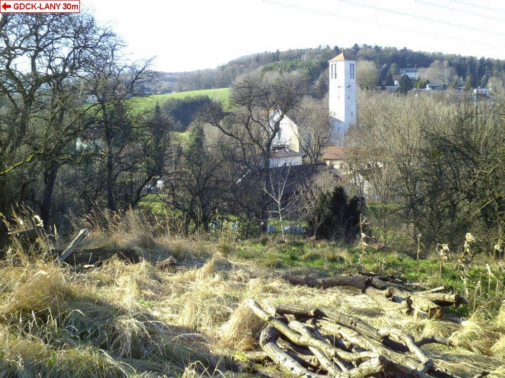
As we passed by the point on our way from Vienna to St. Pölten anyway, I decided to drive up there and see what it's like. As we found out, it had fallen on a hill next to a small village with very complex local name. It was possible to drive to appr. 100m from the point... well, actually there was a road of tractor going uphill from there, quite exactly to the point, but it went through a ditch and was kind of shaky in general, so we decided to better not take it. There were some big felled logs laying around the point and nice overlook to the village downhill.

http://geodashing.gpsgames.org/cgi-bin/dp.pl?dp=GDCK-LANY


Fünfhöf

Geodashing Dashpoint Log
2014-12-28 14:52:29 UTC
GDCK-LAOJ

Player: Haraldpoiss
Team:   FinEst Dashers

GDCK-LAOJ is near Fünfhöf, Austria.

> Date, Points, TeamPoints, Dashpoint, Country, State, Lat, Lon, Distance
2014-12-23, 3, 3, GDCK-LAOJ, Austria, , 47.3125, 15.9455, 0

New extreme east  visit this year for Austria: GDCK-LAOJ
New extreme south visit this year for Austria: GDCK-LAOJ
If this is not correct, please notify the Geodashing Webmaster

Number of previous hunts by Haraldpoiss: 61

As I was on holiday in Austria and didn't get a chance to try out mountain skiing due to high temperatures, I decided to conquer the hills by doing some geodashing instead, together with my wonderful companion who happens to live around there. So first we tried our luck in south-eastern corner of the country, near the village named Fünfhöf, which definitely turned out to be a pleasant experience. It was possible to drive to 105m from the point, where the road ended by a unique privately owned "railway station" next to a farm-house. From there I climbed up along the meadow on the hill-side and made it to zero. There was a wonderful view from the point to the surrounding mountains and villages between them.

http://geodashing.gpsgames.org/cgi-bin/dp.pl?dp=GDCK-LAOJ


a church near the dashpoint

the "railway station" :)