Friday, January 11, 2013

Iruste

Geodashing Dashpoint Log
2013-01-06 19:45:03 UTC
GDBN-MUCK

Player: Haraldpoiss
Team:   FinEst Dashers

GDBN-MUCK is near Kakhutsi, Estonia.

> Date, Points, TeamPoints, Dashpoint, Country, State, Lat, Lon, Distance
2013-01-05, 3, 3, GDBN-MUCK, Estonia, , 58.5110, 23.0191, 0

Number of previous hunts by Haraldpoiss: 37

It was on an open field, next to an old hill-fort. It was possible to drive to 50m. A big animal bone was laying 20m from the point. So after visiting the point, I went to the hill-fort 350m away.. or actually to what's left from it - a 10m high hill. Considering the general flatness of Estonia, a nice view still opened from top of it, including the view to the dashpoint. Looks like it's a good place for sledging, because someone's sledges were laying on the ground there. But there wasn't enough snow for it this day. As it could have been expected, on the way back I was stopped on the road because of over-speeding. It was the "green patrol" this time, which means that they are actually not the police, but the border guard. Theoretically these guys should be spending their time on sea, seeking for these Russian submarines... But no-no, instead of that they are lurking on the road-side in their green van and measuring speed. Anyway, after checking the documents they let me go with no fee.

http://geodashing.gpsgames.org/cgi-bin/dp.pl?dp=GDBN-MUCK

someone's lost bone 20m from GDBN-MUCK
 
view to GDBN-MUCK from 350m from top of Pöide hill-fort
 
Pöide village


Wednesday, January 9, 2013

Nava

Geodashing Dashpoint Log
2013-01-06 19:32:30 UTC
GDBN-MOTY

Player: Haraldpoiss
Team:   FinEst Dashers

GDBN-MOTY is near Nymme, Estonia.

> Date, Points, TeamPoints, Dashpoint, Country, State, Lat, Lon, Distance
2013-01-05, 3, 3, GDBN-MOTY, Estonia, , 58.4956, 22.6711, 0

Number of previous hunts by Haraldpoiss: 36

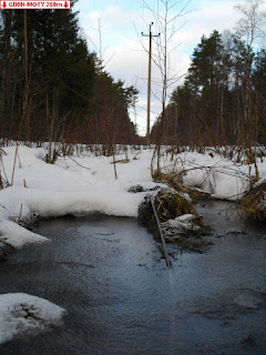
It was a nice winter day. Few degrees minus C, sunny and half-cloudy. It was possible to drive to 800m. From there I took a walk through the forest. There was snow on the ground and occasionally some water. The point was close to a power line, next to a big tree with lot of branches - probably an oak, but I'm not sure, because it had no leaves.

http://geodashing.gpsgames.org/cgi-bin/dp.pl?dp=GDBN-MOTY

a lost wire in ice
 
a bird nest around a tree
 
wooden horses by Angla windmills


Saturday, December 1, 2012

Viidu

Geodashing Dashpoint Log
2012-12-01 21:08:06 UTC
GDBM-MOBU

Player: Haraldpoiss
Team:   FinEst Dashers

GDBM-MOBU is near Viidu, Estonia.

> Date, Points, TeamPoints, Dashpoint, Country, State, Lat, Lon, Distance
2012-12-01, 3, 3, GDBM-MOBU, Estonia, , 58.3120, 22.1375, 0

New extreme west  visit this year for Estonia: GDBM-MOBU
If this is not correct, please notify the Geodashing Webmaster

Number of previous hunts by Haraldpoiss: 35

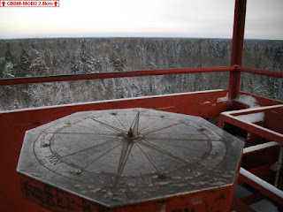
As we didn't yet have snow on last weekend and the temperature was slightly above 0C, today we had beautiful white fresh snow everywhere and chilly -10. The dashpoint was in brush, not far from the highest hill of Saaremaa island, which is 53m above sea level. It was possible to drive to 240m. On the way back I made a little hook and visited a nice viewing tower 2.8km from the point.

http://geodashing.gpsgames.org/cgi-bin/dp.pl?dp=GDBM-MOBU


View toward the dashpoint from top of the tower, erected on the highest hills of Saaremaa


Saturday, November 24, 2012

Karujärve

Geodashing Dashpoint Log
2012-11-24 17:39:56 UTC
GDBL-MOLD

Player: Haraldpoiss
Team:   FinEst Dashers

GDBL-MOLD is near Dejevo, Estonia.

> Date, Points, TeamPoints, Dashpoint, Country, State, Lat, Lon, Distance
2012-11-24, 3, 3, GDBL-MOLD, Estonia, , 58.3828, 22.2405, 0

Number of previous hunts by Haraldpoiss: 34

It was in forest, near Karujärve (the Bear Lake) camping site, which was closed down for winter. As the summer party of my company had taken place there this year, I took the chance to walk around a little and remind it. Yeah, pleasant memories... The road going to the point wasn't the easiest one. Occasionally there were at least 20cm deep rails and puddles, but I made it all the way down and drove to 60m from the point. Back there (about 2km from the point) is an abandoned Soviet military missile base (Dejevo), where a ski resort is situated nowadays. But I didn't visit it, because I've been there couple of times already.

http://geodashing.gpsgames.org/cgi-bin/dp.pl?dp=GDBL-MOLD

A good place for underneath repair works... just don't drive into the channel ;)
 
The camping site, Karujärv (the Beer Lake) on the background and the beer bottle showing way to the dashpoint


Saturday, November 17, 2012

Kübassaare

Geodashing Dashpoint Log
2012-11-17 16:08:26 UTC
GDBL-MURO

Player: Haraldpoiss
Team:   FinEst Dashers

GDBL-MURO is near Kubassaare Asundus, Estonia.

> Date, Points, TeamPoints, Dashpoint, Country, State, Lat, Lon, Distance
2012-11-17, 3, 3, GDBL-MURO, Estonia, , 58.4409, 23.3002, 0

Number of previous hunts by Haraldpoiss: 33

As my plan to visit GDBL-MURO last Saturday, after GDBL-MUHY, failed because of some unexpected challenegs, I decided to do it today. I'm already quite recovered from the cold that I got in GDBL-MUHY and the infection that I picked up after that, so it was nice to finally breath some fresh air after staying inside for most of the week. While driving there, I saw many hunters by the road, armed with guns and wearing orange vests for not to be shot by their fellows. Looks like the open season has started. I parked my car to a nice place, which was a free-to-use camping site, equipped with kitchen and several other facilities. It was 400m from the dashpoint and actually I nearly got stuck there, because the ground was quite soft and soaked. So I walked to the dashpoint, which was on a quite average sea-shore. Basically there was nice view to Udriku bay, some islets in it and the wild Muraja peninsula overseas, but the weather was a little bit dull. 200m from the point was a nice viewing tower. 700m away there was even higher tower, with a radar on top of it, but no climbing to that one - a military object ;) Just took some pictures. As it could have been expected, on the way back there were my "friends" (the police) by the road. As I was going over 100km/h, they stopped me, checked the documents, made me blow to the alcometer and recommended to drive slower. Sure, I did it... for the next kilometer :D

http://geodashing.gpsgames.org/cgi-bin/dp.pl?dp=GDBL-MURO

the free-to-use camping site
 
view to Udriku bay
 
the base of the military radar


Sunday, November 11, 2012

Mehama

Geodashing Dashpoint Log
2012-11-11 17:11:30 UTC
GDBL-MUHY

Player: Haraldpoiss
Team:   FinEst Dashers

GDBL-MUHY is near Linnutaga, Estonia.

> Date, Points, TeamPoints, Dashpoint, Country, State, Lat, Lon, Distance
2012-11-10, 3, 3, GDBL-MUHY, Estonia, , 58.5195, 22.9900, 0

Number of previous hunts by Haraldpoiss: 32

It was an adventure. Total duration of the mission was 7.5h. First I drove to
the place where the gravel road ended. It was about 1km from the point and I
started walking on a meadow. Everything would have been just perfect, but then
I noticed that the dirt road on the edge of the meadow is actually drivable as
well. So I started the car and drove about 500m forward, to the place where the
road became too soft. I left the car there and started walking forward. 200m
from the point I saw the silliest wild boar hunting "tower" that I've ever
seen. It had no cabin, but basically it was just a 5m high ladder leaning to a
birch, a 30x50cm platform on top of it. But it still seemed to be usable,
because 20m away there was a pile of potatos and leftovers from making apple
juice lying on the ground to attract the boars. These animals really never look
up and are dead easy to be shot like that...
The point was in brush and there was nothing special about it. But the real fun
started when I reached back to the car and wanted to drive away. I had come too
far with it and got stuck there. And whatever I did, I just got stuck more and
more. The front wheels just digged in. I lifed up the front corners of the car
by jack and put snow chains around the wheels. I put chocks under the wheels to
create a stronger surface. I walked around, picked some stones and put these
also under the wheels. But nothing helped. I called some friends who I knew
having a rover, to come and help me out. But they didn't pick up. Nice
"friends" indeed. Finally I called to road assistance, who said that they can
come from the town 50km away, which would cost about 100€. Ouch!! Anyway, they recommended me to try to find a household nearby, where is a tractor. Which I did. I walked to a village 1,5km away and asked help from locals. First people that I met there, were an old couple, who happily agreed to help me. So we drove to my car and tried to pull it out. But unsuccessfully, because I was in too deep. Finally their car got stuck as well!! I was very vorried because of messing them into it, but luckily these people knew a man nearby, who has a tractor. So they called him and he came and pulled them out first and then me. Unfortunately the oldies decided to drive away as soon as they got out, so I didn't even get a chance to thank them properly. But the tractor driver told me that the guy was the mayor of a parish nearby. So I was actually hepled by a local top-politician!! The tractor guy asked me 20€ for his service, which I'd of course have happily paid. But I happened to have only €10 in my wallet. So I gave it to him and he said that it's ok. He also gave me his number and encouraged me to call him next time when I should get stuck nearby. No problem man, I'll definitely do it ;) So if any of you who happens to read this, will ever get stuck anywhere near Orissaare, or would need a tractor down there for whatever reason, please don't hesitate to call +372 56490565. Thank you man, I really appreciated your help!!

http://geodashing.gpsgames.org/cgi-bin/dp.pl?dp=GDBL-MUHY

A ladder used for hunting wild boars

a "land" border sign

it was so fresh in there...

Saturday, October 6, 2012

Metsaküla

Geodashing Dashpoint Log
2012-10-06 19:03:04 UTC
GDBK-MOVU

Player: Haraldpoiss
Team:   FinEst Dashers

GDBK-MOVU is near Metsa Asundus, Estonia.

> Date, Points, TeamPoints, Dashpoint, Country, State, Lat, Lon, Distance
2012-10-06, 3, 3, GDBK-MOVU, Estonia, , 58.3435, 22.8067, 0

Number of previous hunts by Haraldpoiss: 31

The first approach was unsuccessful. I drove to 700m, but the point was on the
other side of a 3m wide deep trench. Then I tried from another direction, where
it was possible to drive to 900m. Most interesting things I saw: a wild boar
hunting tower, brush with fallen trees and trenches, water on the ground,
several kind of berries, a small partially wet cattle road with bullshit and
footprints, a nice meadow, a power line, mushrooms on the ground and on trees,
a bullshit laying trailer, a strange hut next to the cattle road, a farm house,
cows on a pastory and cat-tails (the plants). The point was in brush, 25m from
the power line. Some mushrooms were growing there.

http://geodashing.gpsgames.org/cgi-bin/dp.pl?dp=GDBK-MOVU

a trench on the way to GDBK-MOVU
 

a bullshit laying trailer