Wednesday, February 12, 2014

Mätasselja

Geodashing Dashpoint Log
2014-02-12 12:44:55 UTC
GDCA-MOAR

Player: Haraldpoiss
Team:   FinEst Dashers

GDCA-MOAR is near Kärla, Estonia.

> Date, Points, TeamPoints, Dashpoint, Country, State, Lat, Lon, Distance
2014-02-12, 3, 3, GDCA-MOAR, Estonia, , 58.3195, 22.1655, 0

Number of previous hunts by Haraldpoiss: 48

What was a dull cloudy morning in town, turned to blindingly sunny winter day in nature. As I've been lately quite busy, I didn't have time to mess with buses this time, but drove to the point instead. It was possible to drive to 300m distance after successfully passing the "Private property" sign. From there I walked over a clearance and last 50m in forest.

http://geodashing.gpsgames.org/cgi-bin/dp.pl?dp=GDCA-MOAR


Luckily the ice was carrying, despite of above-zero temperature

a nice bus-stop

Sunday, January 26, 2014

Länga

Geodashing Dashpoint Log
2014-01-26 15:14:43 UTC
GDBZ-MOCO

Player: Haraldpoiss
Team:   FinEst Dashers

GDBZ-MOCO is near Lassi, Estonia.

> Date, Points, TeamPoints, Dashpoint, Country, State, Lat, Lon, Distance
2014-01-22, 3, 3, GDBZ-MOCO, Estonia, , 58.2129, 22.1893, 0

Number of previous hunts by Haraldpoiss: 47

It was a beautiful sunny winter day with chilly -10C outside.
13:51 the bus dropped me to straight distance 3.6km from the point, where from i walked then. It took me little bit more than an hour to reach there. The point was in brush, and there was nothing especially interesting around it. After zeroing the GPS, I took a longer walk in surrounding forest. I saw a couple of black roes twice, but they ran away to between trees too fast to take a picture.
17:10 it was getting really dark and i started walking back to the bus. I reached to the stop about 45min too early, so i started walking towards home. I managed to walk 3 bus stops (3.7km) like that before the bus came.
19:39 the bus picked me up. For that time I hadn't drinken a sip of water during almost 6 hours. So i finally felt a bit thursty and took the bottle from the side-pocket of my jacket. And at least half of the water in it had frozen to ice.

http://geodashing.gpsgames.org/cgi-bin/dp.pl?dp=GDBZ-MOCO


Hit the road, Jack...

Left way or right way - choice is yours. Only that the right one is actually a ditch.

I'm not quite sure what this is, but the sign on the low concrete post says "A geodesic point under protection of Estonian Republic". Maybe I should have taken my hat off and sang the anthem?

Tuesday, January 21, 2014

Tatterselja 2

Geodashing Dashpoint Log
2013-12-31 20:57:52 UTC
GDBY-MOJI

Player: Haraldpoiss
Team:   FinEst Dashers

GDBY-MOJI is near Kõrkküla, Estonia.

> Date, Points, TeamPoints, Dashpoint, Country, State, Lat, Lon, Distance
2013-12-08, 3, 3, GDBY-MOJI, Estonia, , 58.2261, 22.2633, 0

New extreme south visit this year for Estonia: GDBY-MOJI
If this is not correct, please notify the Geodashing Webmaster

Number of previous hunts by Haraldpoiss: 46

It was a beautiful day with the very first fresh snow of this winter and slight minus temperature. Bus dropped me 3km from the destination. From there i found my way from between and through all these cottages and f&%#*ng private properties to the swamp behind them. There whole swamp was covered with the white snow that had fallen allover the plants. But underneath there was unfrozen water. Not too deep to get through with boots though. The point was in reed that was higher than my head, so nothing could be seen from there. Afterwards i took a longer walk in the swamp and nearby forest. On the way back a nice big dog started following me for i don't know what reason. And he wanted very willingly to join me on the bus back, but I didn't let him on board though.

http://geodashing.gpsgames.org/cgi-bin/dp.pl?dp=GDBY-MOJI


on the edge of the swamp

yes, i came through it

my faithful companion

Monday, November 11, 2013

Kõnnu

Geodashing Dashpoint Log
2013-11-11 19:41:42 UTC
GDBX-MOOR

Player: Haraldpoiss
Team:   FinEst Dashers

GDBX-MOOR is near Kõljala, Estonia.

> Date, Points, TeamPoints, Dashpoint, Country, State, Lat, Lon, Distance
2013-11-02, 3, 3, GDBX-MOOR, Estonia, , 58.3458, 22.6832, 0

Number of previous hunts by Haraldpoiss: 45

Like i've been lately trying to do, also on this time I decided to enjoy the features of local bus traffic. The point was just 19km from my home anyway. It was on a meadow, few meters from forest. After visiting, i took a longer walk in the forest behind it. When i wanted to take the bus back, the bus driver almost drove by me when i was standing in the bus stop. Only after I raised my hand, he finally stopped about 30-40m past me. That was a close one, but eventually i still got on it. And of course it was the last bus back on that day. Next morning i discovered a tick from the skin of my stomach. Dead. I must be poisonous.

http://geodashing.gpsgames.org/cgi-bin/dp.pl?dp=GDBX-MOOR


A tick on my GPS. Next day there was another one on my stomach.

That one was pointing to the dashpoint

Sunday, October 13, 2013

Tamse

Geodashing Dashpoint Log
2013-10-13 19:10:01 UTC
GDBW-MUIP

Player: Haraldpoiss
Team:   FinEst Dashers

GDBW-MUIP is near Kapi, Estonia.

> Date, Points, TeamPoints, Dashpoint, Country, State, Lat, Lon, Distance
2013-10-13, 3, 3, GDBW-MUIP, Estonia, , 58.6522, 23.1384, 0

New extreme north visit this year for Estonia: GDBW-MUIP
New extreme east  visit this year for Estonia: GDBW-MUIP
If this is not correct, please notify the Geodashing Webmaster

Number of previous hunts by Haraldpoiss: 44

I'm devoting this visit to Vera, the most fantastic girl I've ever met in this world.

I could have just driven there of course, but that would have been a little bit too easy and boring. So I took a bus to Liiva 7km away and walked from there. The weather was nice and there were beautiful autumnal colors everywhere.

After leaving the main road, the traffic become very sparse, so during 4km only 5 cars passed by me. And 2 of them stopped to offer me a lift!!! Crazy friendly people of Muhu island ;) But as i had the 4.5h walk planned already, I refused politely. The point was only 100 meters from sea, on a sheep pasture. So basically I shouldn't have gone there, but - who cares, I still did it :D There were Koinastu islets and a peninsula visible over Lopemeri bay.

After the visit I took a bus from the nearby (2km away) bus stop to Kuivastu harbor and from there another one back home. I saw a magnificent sunset over strait Väike on the way back.

http://geodashing.gpsgames.org/cgi-bin/dp.pl?dp=GDBW-MUIP


Rannaküla boat harbor

It was somewhere in this reed

Tamse village

Saturday, September 7, 2013

Tatterselja

Geodashing Dashpoint Log
2013-09-07 17:58:19 UTC
GDBV-MOIT

Player: Haraldpoiss
Team:   FinEst Dashers

GDBV-MOIT is near Kõrkküla, Estonia.

> Date, Points, TeamPoints, Dashpoint, Country, State, Lat, Lon, Distance
2013-09-07, 3, 3, GDBV-MOIT, Estonia, , 58.2272, 22.2532, 0

New extreme south visit this year for Estonia: GDBV-MOIT
New extreme west  visit this year for Estonia: GDBV-MOIT
If this is not correct, please notify the Geodashing Webmaster

Number of previous hunts by Haraldpoiss: 43

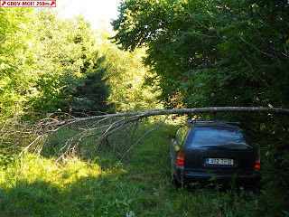
It was possible to drive to 130m, but it was a small road through the woods and so rarely used that occasionally the grass on it was actually higher then my head while I was sitting in car. Finally a fallen tree over it made me stop. Then I walked, but it was not so easy either, as there were a lot of unpassable muddy pools there and I had to find my way around these. The point was in reed, plants higher then my head while I was standing there. Afterwards I took a 3h walk in nerby swamp, reed, forest and meadows. The weather was warm and sunny. In the woods I saw a wild boar from very close-up. A tractor was cutting down hey on a meadow, but this hey was actually very mixed up with reed.

http://geodashing.gpsgames.org/cgi-bin/dp.pl?dp=GDBV-MOIT


a low passage...

a strange mushroom on a tree, 1.3km from GDBV-MOIT
 
a wild boar hunting tower on a meadow
 

Rannaküla (Valjala parish)

Geodashing Dashpoint Log
2013-09-07 16:38:00 UTC
GDBV-MUBU

Player: Haraldpoiss
Team:   FinEst Dashers

GDBV-MUBU is near Laimjala, Estonia.

> Date, Points, TeamPoints, Dashpoint, Country, State, Lat, Lon, Distance
2013-09-01, 3, 3, GDBV-MUBU, Estonia, , 58.3824, 22.9591, 1

New extreme south visit this year for Estonia: GDBV-MUBU
If this is not correct, please notify the Geodashing Webmaster

Number of previous hunts by Haraldpoiss: 42

This point was in sea, 140m from coast of Saaremaa and 24m from the closest islet. Water was only 0.5m deep, so basically I could have walked there through the sea, but as I had taken my kayak with me, I used this of course. The bottom and the shores around there were quite soft and muddy anyway. As I was there already, I made a longer tour on the beautiful Kunnati and Kõiguste bays afterwards. It was rather windy out there at this day, but quite ok otherwise.

http://geodashing.gpsgames.org/cgi-bin/dp.pl?dp=GDBV-MUBU


it was on the northern coast of Kunnati bay

prior to departure from Rannaküla "beach"

local wool-balls