Monday, August 5, 2013

Eikla

Geodashing Dashpoint Log
2013-08-05 16:02:48 UTC
GDBU-MOUH

Player: Haraldpoiss
Team:   FinEst Dashers

GDBU-MOUH is near Kaarma, Estonia.

> Date, Points, TeamPoints, Dashpoint, Country, State, Lat, Lon, Distance
2013-08-02, 3, 3, GDBU-MOUH, Estonia, , 58.4187, 22.5102, 1

New extreme south visit this year for Estonia: GDBU-MOUH
New extreme west  visit this year for Estonia: GDBU-MOUH
If this is not correct, please notify the Geodashing Webmaster

Number of previous hunts by Haraldpoiss: 41

I did something extraordinary this time. For a change I took a BUS to the dashpoint. Because it was quite easily accessible by bus ;) It was on the outskirts of village Eikla, on a meadow, 160m from a road. I guess the people living in the houses around the meadow must have found it quite weird to see a strange guy just aimlessly walking out there.

After visiting the point, I took a longer walk in nearby forest. When I wanted to take the bus back to town, a bad surprise occurred to me. The bus had either come too early or didn't come at all. Anyway, it didn't show up. And there was 3,5h to the next bus. Which means I walked 3 more hours in the forest :D
I wanted to buy some snack from the village shop before that, but the shop was closed already, because it was after 5pm.

List of noteworthy objects I saw:
a grain harvester
rowans
apples
an abandoned cabin in forest
blackberries
blueberries
lingonberries
an abandoned petrol station
wild strawberries
wild raspberries
a tractor on roadside which trailer had a flat tyre

http://geodashing.gpsgames.org/cgi-bin/dp.pl?dp=GDBU-MOUH


Before departure from Kuressaare bus station
 
 
a butterfly on a flower, 1km from dashpoint
 

Saturday, June 1, 2013

Laugu

Geodashing Dashpoint Log
2013-06-01 17:49:00 UTC
GDBS-MORE

Player: Haraldpoiss
Team:   FinEst Dashers

GDBS-MORE is near Laugu, Estonia.

> Date, Points, TeamPoints, Dashpoint, Country, State, Lat, Lon, Distance
2013-06-01, 3, 3, GDBS-MORE, Estonia, , 58.5747, 22.5934, 0

New extreme west  visit this year for Estonia: GDBS-MORE
If this is not correct, please notify the Geodashing Webmaster

Number of previous hunts by Haraldpoiss: 40

It was a warm and sunny summer day. The point was in a swampy forest with some mosquitoes, behind the nice village Laugu. Small country roads took me to 65m from the point, so it was a drive-in. There were delicious young tips on the branches of spruces, of which I had nice fresh addition to my breakfast. Afterwards I took a 2.5h walk on the beach and in coastal forest. It was nice as well. Wild strawberries and some flowers were blooming under the forest and I also tasted some wood sorrel. There were lots of plants of berries, but of course right now the berries are not even green yet. On the coast there were some tied-up boats and several free-to-use public camping sites.

http://geodashing.gpsgames.org/cgi-bin/dp.pl?dp=GDBS-MORE


A funny fisherman in village Leisi

A small stream crossing the road. Believe me or not, it was the road to dashpoint.

Two stones painted as a most typical Estonian family: a woman with a child. The sign is saying: "The father is at work in Finland". It's very common for Estonians to go to work to Finland to get better salary. Because here people are really not paid, but made fun of. Back there is a spruce with the bright green fresh tips of branches. These can be eaten even with no salary.

Saturday, April 6, 2013

Rannaküla (Orissaare parish)

Geodashing Dashpoint Log
2013-04-06 11:35:09 UTC
GDBQ-MOWY

Player: Haraldpoiss
Team:   FinEst Dashers

GDBQ-MOWY is near Randkula, Estonia.

> Date, Points, TeamPoints, Dashpoint, Country, State, Lat, Lon, Distance
2013-04-06, 3, 3, GDBQ-MOWY, Estonia, , 58.6159, 22.8610, 0

Number of previous hunts by Haraldpoiss: 39

It was a blindingly sunny winter day. There were no cops on the road and I overtook several cars, including two of my colleagues, one of which happened to be my boss. People really are driving like snails around here, no kidding ;) So I drove to the small harbor in Rannaküla and left my car there, 600m from the point. First I walked a little bit westward over sea-ice. It was so beautiful and all white. There was no wind and the sun was warm. A surveillance radar and Hiiumaa island were visible in distance. Then I walked 400m through forest to the point. It was a nice coastal pine forest with little bushes and some big stones inside. The point was on a bushy meadow in the middle of junipers.

http://geodashing.gpsgames.org/cgi-bin/dp.pl?dp=GDBQ-MOWY


Rannaküla harbor building

it was a small harbor...

Rannaküla

Saturday, March 2, 2013

Kõinastu

Geodashing Dashpoint Log
2013-03-02 21:53:09 UTC
GDBP-MUAZ

Player: Haraldpoiss
Team:   FinEst Dashers

GDBP-MUAZ is near Koinastu, Estonia.

> Date, Points, TeamPoints, Dashpoint, Country, State, Lat, Lon, Distance
2013-03-02, 3, 3, GDBP-MUAZ, Estonia, , 58.6286, 23.0346, 0

Number of previous hunts by Haraldpoiss: 38

Wow-wow-wow, it's Haraldpoiss with breaking news from Saaremaa, reporting another overseas dashpoint visit. It was on a small islet, near island Muhu.

We had a nice sunny winter day with chilly -10C outside. Approaching to the dashpoint, I first took a wrong way, which ended with a sign "Private property". Oh, how I just love these. As the road was narrow and there was deep snow on both sides, there was no possibility to turn around. So I had to reverse for about 0.5km. Oh yes, and of course I was not careful enough with it and drove too close to the side of the road and got stuck. It took me half an hour to get out from there. Nothing serious though.

So, I took the right way after that, which had quite bad snow conditions. The semi-hard snow between the driving tracks was continuously scraping the bottom of the car. It should have taken me to the shore, where from the point 2.2km away should have been walked to. Well, that's not the way I do business ;) It was quite cold and windy out there on the open sea... and there were some tracks on the ice, which looked like an unofficial ice road. So I drove onto the sea and made it to 460m from the point. Basically I parked in the middle of the sea and walked from there to make it zero. It was on the outskirts of islet Kõinastu.

While I was careful when approaching, on the way back I made easily over 100km/h on ice. It felt like driving on a dried salt lake or something. It was fun. And I didn't wear seat belt of course, because it's illegal to wear it on ice (as it is actually illegal to drive on ice anyway). Back on dry land, I saw a nice fox on roadside, but it ran away as soon as I stopped, so I couldn't take a picture. Afterwards I visited Muhu hill-fort and saw kite surfers on the ice of strait Väike. Road conditions were excellent and for my big surprise, I didn't see cops this time nor any other phenomena that may disturb fluent traffic.

http://geodashing.gpsgames.org/cgi-bin/dp.pl?dp=GDBP-MUAZ


In the beginning of ice-road, shore of Saaremaa visible over sea

Parking in the middle of sea, shore of Saaremaa visible on horizon

As we've had few weeks of quite warm weather, the leaves are about to burst out already. On top of the rampart of Muhu stronghold, 9.5km from GDBP-MUAZ.

Friday, January 11, 2013

Iruste

Geodashing Dashpoint Log
2013-01-06 19:45:03 UTC
GDBN-MUCK

Player: Haraldpoiss
Team:   FinEst Dashers

GDBN-MUCK is near Kakhutsi, Estonia.

> Date, Points, TeamPoints, Dashpoint, Country, State, Lat, Lon, Distance
2013-01-05, 3, 3, GDBN-MUCK, Estonia, , 58.5110, 23.0191, 0

Number of previous hunts by Haraldpoiss: 37

It was on an open field, next to an old hill-fort. It was possible to drive to 50m. A big animal bone was laying 20m from the point. So after visiting the point, I went to the hill-fort 350m away.. or actually to what's left from it - a 10m high hill. Considering the general flatness of Estonia, a nice view still opened from top of it, including the view to the dashpoint. Looks like it's a good place for sledging, because someone's sledges were laying on the ground there. But there wasn't enough snow for it this day. As it could have been expected, on the way back I was stopped on the road because of over-speeding. It was the "green patrol" this time, which means that they are actually not the police, but the border guard. Theoretically these guys should be spending their time on sea, seeking for these Russian submarines... But no-no, instead of that they are lurking on the road-side in their green van and measuring speed. Anyway, after checking the documents they let me go with no fee.

http://geodashing.gpsgames.org/cgi-bin/dp.pl?dp=GDBN-MUCK

someone's lost bone 20m from GDBN-MUCK
 
view to GDBN-MUCK from 350m from top of Pöide hill-fort
 
Pöide village


Wednesday, January 9, 2013

Nava

Geodashing Dashpoint Log
2013-01-06 19:32:30 UTC
GDBN-MOTY

Player: Haraldpoiss
Team:   FinEst Dashers

GDBN-MOTY is near Nymme, Estonia.

> Date, Points, TeamPoints, Dashpoint, Country, State, Lat, Lon, Distance
2013-01-05, 3, 3, GDBN-MOTY, Estonia, , 58.4956, 22.6711, 0

Number of previous hunts by Haraldpoiss: 36

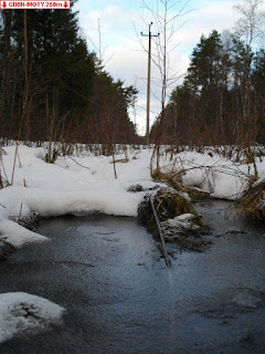
It was a nice winter day. Few degrees minus C, sunny and half-cloudy. It was possible to drive to 800m. From there I took a walk through the forest. There was snow on the ground and occasionally some water. The point was close to a power line, next to a big tree with lot of branches - probably an oak, but I'm not sure, because it had no leaves.

http://geodashing.gpsgames.org/cgi-bin/dp.pl?dp=GDBN-MOTY

a lost wire in ice
 
a bird nest around a tree
 
wooden horses by Angla windmills


Saturday, December 1, 2012

Viidu

Geodashing Dashpoint Log
2012-12-01 21:08:06 UTC
GDBM-MOBU

Player: Haraldpoiss
Team:   FinEst Dashers

GDBM-MOBU is near Viidu, Estonia.

> Date, Points, TeamPoints, Dashpoint, Country, State, Lat, Lon, Distance
2012-12-01, 3, 3, GDBM-MOBU, Estonia, , 58.3120, 22.1375, 0

New extreme west  visit this year for Estonia: GDBM-MOBU
If this is not correct, please notify the Geodashing Webmaster

Number of previous hunts by Haraldpoiss: 35

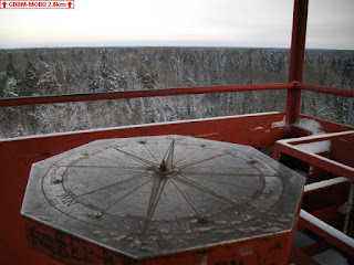
As we didn't yet have snow on last weekend and the temperature was slightly above 0C, today we had beautiful white fresh snow everywhere and chilly -10. The dashpoint was in brush, not far from the highest hill of Saaremaa island, which is 53m above sea level. It was possible to drive to 240m. On the way back I made a little hook and visited a nice viewing tower 2.8km from the point.

http://geodashing.gpsgames.org/cgi-bin/dp.pl?dp=GDBM-MOBU


View toward the dashpoint from top of the tower, erected on the highest hills of Saaremaa