Sunday, December 28, 2014

Innermanzing

Geodashing Dashpoint Log
2014-12-28 15:57:22 UTC
GDCK-LANY

Player: Haraldpoiss
Team:   FinEst Dashers

GDCK-LANY is near Neustift Bei Altlengbach, Austria.

> Date, Points, TeamPoints, Dashpoint, Country, State, Lat, Lon, Distance
2014-12-24, 3, 3, GDCK-LANY, Austria, , 48.1320, 15.9155, 0

Number of previous hunts by Haraldpoiss: 62

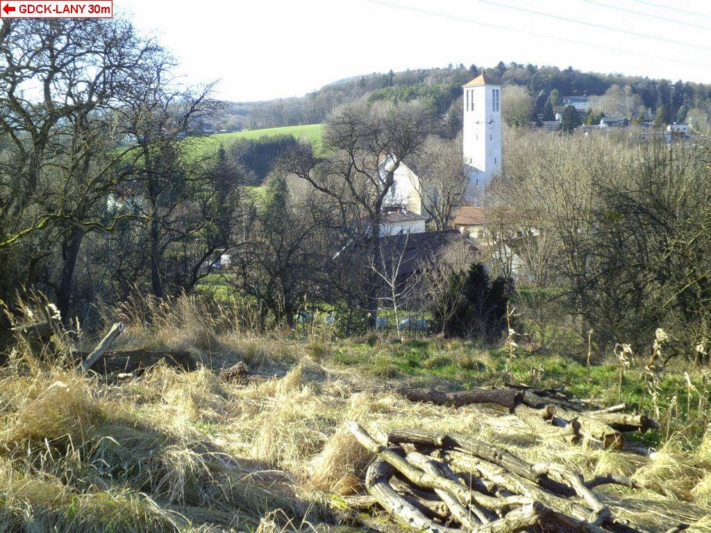
As we passed by the point on our way from Vienna to St. Pölten anyway, I decided to drive up there and see what it's like. As we found out, it had fallen on a hill next to a small village with very complex local name. It was possible to drive to appr. 100m from the point... well, actually there was a road of tractor going uphill from there, quite exactly to the point, but it went through a ditch and was kind of shaky in general, so we decided to better not take it. There were some big felled logs laying around the point and nice overlook to the village downhill.

http://geodashing.gpsgames.org/cgi-bin/dp.pl?dp=GDCK-LANY


Fünfhöf

Geodashing Dashpoint Log
2014-12-28 14:52:29 UTC
GDCK-LAOJ

Player: Haraldpoiss
Team:   FinEst Dashers

GDCK-LAOJ is near Fünfhöf, Austria.

> Date, Points, TeamPoints, Dashpoint, Country, State, Lat, Lon, Distance
2014-12-23, 3, 3, GDCK-LAOJ, Austria, , 47.3125, 15.9455, 0

New extreme east  visit this year for Austria: GDCK-LAOJ
New extreme south visit this year for Austria: GDCK-LAOJ
If this is not correct, please notify the Geodashing Webmaster

Number of previous hunts by Haraldpoiss: 61

As I was on holiday in Austria and didn't get a chance to try out mountain skiing due to high temperatures, I decided to conquer the hills by doing some geodashing instead, together with my wonderful companion who happens to live around there. So first we tried our luck in south-eastern corner of the country, near the village named Fünfhöf, which definitely turned out to be a pleasant experience. It was possible to drive to 105m from the point, where the road ended by a unique privately owned "railway station" next to a farm-house. From there I climbed up along the meadow on the hill-side and made it to zero. There was a wonderful view from the point to the surrounding mountains and villages between them.

http://geodashing.gpsgames.org/cgi-bin/dp.pl?dp=GDCK-LAOJ


a church near the dashpoint

the "railway station" :)


Saturday, December 20, 2014

Lalli

Geodashing Dashpoint Log
2014-12-14 11:08:34 UTC
GDCK-MULA

Player: Haraldpoiss
Team:   FinEst Dashers

GDCK-MULA is near Hellamaa, Estonia.

> Date, Points, TeamPoints, Dashpoint, Country, State, Lat, Lon, Distance
2014-12-07, 3, 3, GDCK-MULA, Estonia, , 58.6301, 23.3459, 0

New extreme north visit this year for Estonia: GDCK-MULA
New extreme east  visit this year for Estonia: GDCK-MULA
If this is not correct, please notify the Geodashing Webmaster

Number of previous hunts by Haraldpoiss: 60

It was a sunny day in the end of winter. It was possible to drive to 150m from the point, from where I took a walk. The point was on a clear cut area of forest. After reaching to zero, I walked to the northern coast of island Muhu through the junipers. It was kind of nice, but the problem was that the junipers were annoyingly wet, which is common during this season. On the coast it was very beautiful, however. Mainland and some neighboring islands were visible over sea and there was a big cargo ship on the strait.

http://geodashing.gpsgames.org/cgi-bin/dp.pl?dp=GDCK-MULA


Private land... sorry guys, but I already came through it :)


Wood export

Saturday, November 8, 2014

Lahetaguse

Geodashing Dashpoint Log
2014-11-08 09:01:23 UTC
GDCJ-MIWU

Player: Haraldpoiss
Team:   FinEst Dashers

GDCJ-MIWU is near Lassi, Estonia.

> Date, Points, TeamPoints, Dashpoint, Country, State, Lat, Lon, Distance
2014-11-02, 3, 3, GDCJ-MIWU, Estonia, , 58.1855, 22.0620, 0

New extreme west  visit this year for Estonia: GDCJ-MIWU
If this is not correct, please notify the Geodashing Webmaster

Number of previous hunts by Haraldpoiss: 59

It was possible to drive to 800m from the point, after what the road conditions became really bad. And when I tried to turn around, I got stuck and couldn't get out otherwise than walking to the nearby village and finding someone, who had a tractor and agreed to come and pull me out. As it was dark then already, I decided to go back home after that and not to try to reach to the point this night. On the following day I went there again. This time I stopped little bit before the road became too soft and walked onward to the point along the coastline. There were some junipers and reed and coastal meadows on the way. The point was on the coast, about 20m from sea. Afterwards I took a longer walk by the sea. It was very windy and quite cold and I was happy when I finally reached back to the car - in the dark once again.

http://geodashing.gpsgames.org/cgi-bin/dp.pl?dp=GDCJ-MIWU


I decided to not try this road - not on foot nor by car

a bench with sea view

crossing a river

Monday, October 6, 2014

Mustla

Geodashing Dashpoint Log
2014-10-06 17:50:49 UTC
GDCI-MUJA

Player: Haraldpoiss
Team:   FinEst Dashers

GDCI-MUJA is near Laimjala, Estonia.

> Date, Points, TeamPoints, Dashpoint, Country, State, Lat, Lon, Distance
2014-10-05, 3, 3, GDCI-MUJA, Estonia, , 58.4434, 23.0391, 0

Number of previous hunts by Haraldpoiss: 58

It was a sunny, but windy day in the beginning of October. The point had fallen into the picturesque village named Mustla, about 1km from a bigger road. The exact location happened to be in a corner of the yard around a farm-house. No-one seemed to be home there, at least not outside, and it was nicely between some trees and bushes, so I managed to make it to zero.

http://geodashing.gpsgames.org/cgi-bin/dp.pl?dp=GDCI-MUJA


Ridala village on the right, Jõe village on the left side of the road

Beware, there are greenhouse gases

Let's be strict - it's shit

Saturday, September 27, 2014

Väike-Rahula

Geodashing Dashpoint Log
2014-09-27 19:07:38 UTC
GDCH-MUCI

Player: Haraldpoiss
Team:   FinEst Dashers

GDCH-MUCI is near Suur-pahila, Estonia.

> Date, Points, TeamPoints, Dashpoint, Country, State, Lat, Lon, Distance
2014-09-07, 3, 3, GDCH-MUCI, Estonia, , 58.5577, 22.9347, 0

New extreme north visit this year for Estonia: GDCH-MUCI
If this is not correct, please notify the Geodashing Webmaster

Number of previous hunts by Haraldpoiss: 57

It was a nice and warm day in the beginning of September. Bus dropped me to 6km
from the point, from where I walked. The point was in woods and on the way to
it was kind of a big trench. It took some creativity to cross it, but after
some effort I made it with dry feet.

http://geodashing.gpsgames.org/cgi-bin/dp.pl?dp=GDCH-MUCI


A fly agaric 50m from GDCH-MUCI

A view from a tower in the middle of a meadow, erected for hunting wild boars

Moon above a farm

Sunday, August 3, 2014

Kõnnu 2

Geodashing Dashpoint Log
2014-08-03 19:40:26 UTC
GDCG-MOUP

Player: Haraldpoiss
Team:   FinEst Dashers

GDCG-MOUP is near Reo, Estonia.

> Date, Points, TeamPoints, Dashpoint, Country, State, Lat, Lon, Distance
2014-08-03, 3, 3, GDCG-MOUP, Estonia, , 58.3284, 22.6942, 0

Number of previous hunts by Haraldpoiss: 56

It was about 50m from a small road, but I decided to walk there from a bigger road through forest. During the walk there and back I ate blackberries, raspberries, wood sorrel and a single blackcurrant. The point was in forest, next to some fallen trees.

http://geodashing.gpsgames.org/cgi-bin/dp.pl?dp=GDCG-MOUP


I'm not 100% sure what exactly is there, but on the sign there is written "Archaeological monument settlement place is under national protection".
I didn't go in there either, because I was in shorts and there were lots of nettles.

Wild raspberries

A butterfly on the road-side

Saturday, July 19, 2014

Turja

Geodashing Dashpoint Log
2014-07-19 19:52:21 UTC
GDCF-MOYH

Player: Haraldpoiss
Team:   FinEst Dashers

GDCF-MOYH is near Kase, Estonia.

> Date, Points, TeamPoints, Dashpoint, Country, State, Lat, Lon, Distance
2014-07-19, 3, 3, GDCF-MOYH, Estonia, , 58.3428, 22.9178, 0

Number of previous hunts by Haraldpoiss: 55

I parked my car 200m from the point and walked from there over a meadow. The
point was in forest and there were some wild strawberries growing next to it.

http://geodashing.gpsgames.org/cgi-bin/dp.pl?dp=GDCF-MOYH


Do you wanna get high...

Wild strawberries in dashpoint

3 beauties having dinner

Friday, July 4, 2014

Jämaja

Geodashing Dashpoint Log
2014-07-04 20:27:35 UTC
GDCF-MIYG

Player: Haraldpoiss
Team:   FinEst Dashers

GDCF-MIYG is near Lassi, Estonia.

> Date, Points, TeamPoints, Dashpoint, Country, State, Lat, Lon, Distance
2014-07-03, 3, 3, GDCF-MIYG, Estonia, , 58.0019, 22.0624, 0

New extreme south visit this year for Estonia: GDCF-MIYG
New extreme west  visit this year for Estonia: GDCF-MIYG
If this is not correct, please notify the Geodashing Webmaster

Number of previous hunts by Haraldpoiss: 54

It was possible to drive to 800m, where the road ended with "Private property" sign. From there I walked through the forest and over meadows. The last 100 meters were quite difficult. There was very wet and soft swamp. It was possible to move on only by stepping from sod to sod, keeping good balance. The point was behind the swamp, in sparse forest.

http://geodashing.gpsgames.org/cgi-bin/dp.pl?dp=GDCF-MIYG


the swamp


a black snail in dashpoint

Wednesday, June 11, 2014

Suure-Rootsi

Geodashing Dashpoint Log
2014-06-11 18:46:17 UTC
GDCE-MOUV

Player: Haraldpoiss
Team:   FinEst Dashers

GDCE-MOUV is near Pihtla, Estonia.

> Date, Points, TeamPoints, Dashpoint, Country, State, Lat, Lon, Distance
2014-06-11, 3, 3, GDCE-MOUV, Estonia, , 58.2161, 22.7316, 0

Number of previous hunts by Haraldpoiss: 53

So I parked my car in the end of a small road, beside a fire-place on the coast, exactly 666 meters from the point. According to map, the point should have been on coast line also. However, in reality it was kind of far from sea, in reed over my head, mixed with some "fabulous" nettles :) There was no view from it. After visiting I took a 5km walk on the coastal meadows. I met a herd of young (peaceful) bulls, their lost horn, a roe and a tipi tent on the shore of a lake. Weather was nice and afterwards I went swimming to the sea.

http://geodashing.gpsgames.org/cgi-bin/dp.pl?dp=GDCE-MOUV


Dad and son. With nice ear-clips :)

Horny? ;)

It would have been a nice coastline to walk in shorts and sandals, if there wouldn't have been these nettles!!

Thursday, June 5, 2014

Kõrkküla

Player: Haraldpoiss
Team:   FinEst Dashers

GDCE-MOIN is near Kõrkküla, Estonia.

> Date, Points, TeamPoints, Dashpoint, Country, State, Lat, Lon, Distance
2014-06-05, 3, 3, GDCE-MOIN, Estonia, , 58.2387, 22.2765, 0

Number of previous hunts by Haraldpoiss: 52

It's already at least 3rd dashpoint, that has fallen into the big swamp next to village Kõrkküla. Bus dropped me to 4km from the destination, from where I found my way to the point. I saw a wild boar, a roe (twice), a small snake and blooming strawberries. It's so many mosquitoes there in the woods, that it was almost impossible to stop for taking pictures. And of course I had forgotten to take my anti-mosquito with me. In the swamp it was better however, because there was very nice and hot and sunny and no mosquitoes. Just some huge biting horseflies.

http://geodashing.gpsgames.org/cgi-bin/dp.pl?dp=GDCE-MOIN


Barrel sauna, tunnel sauna and some other sauna... in the middle of woods

A lonely tree and a wild boar hunting tower in the middle of swamp. Actually I've been there before because of another dashpoint.

Hunting zone - something that I saw first time. Beware...

Sunday, May 4, 2014

Puka

Geodashing Dashpoint Log
2014-05-04 19:05:06 UTC
GDCD-MUHY

Player: Haraldpoiss
Team:   FinEst Dashers

GDCD-MUHY is near Tornimäe, Estonia.

> Date, Points, TeamPoints, Dashpoint, Country, State, Lat, Lon, Distance
2014-05-04, 3, 3, GDCD-MUHY, Estonia, , 58.4874, 23.0498, 0

New extreme east  visit this year for Estonia: GDCD-MUHY
If this is not correct, please notify the Geodashing Webmaster

Number of previous hunts by Haraldpoiss: 51

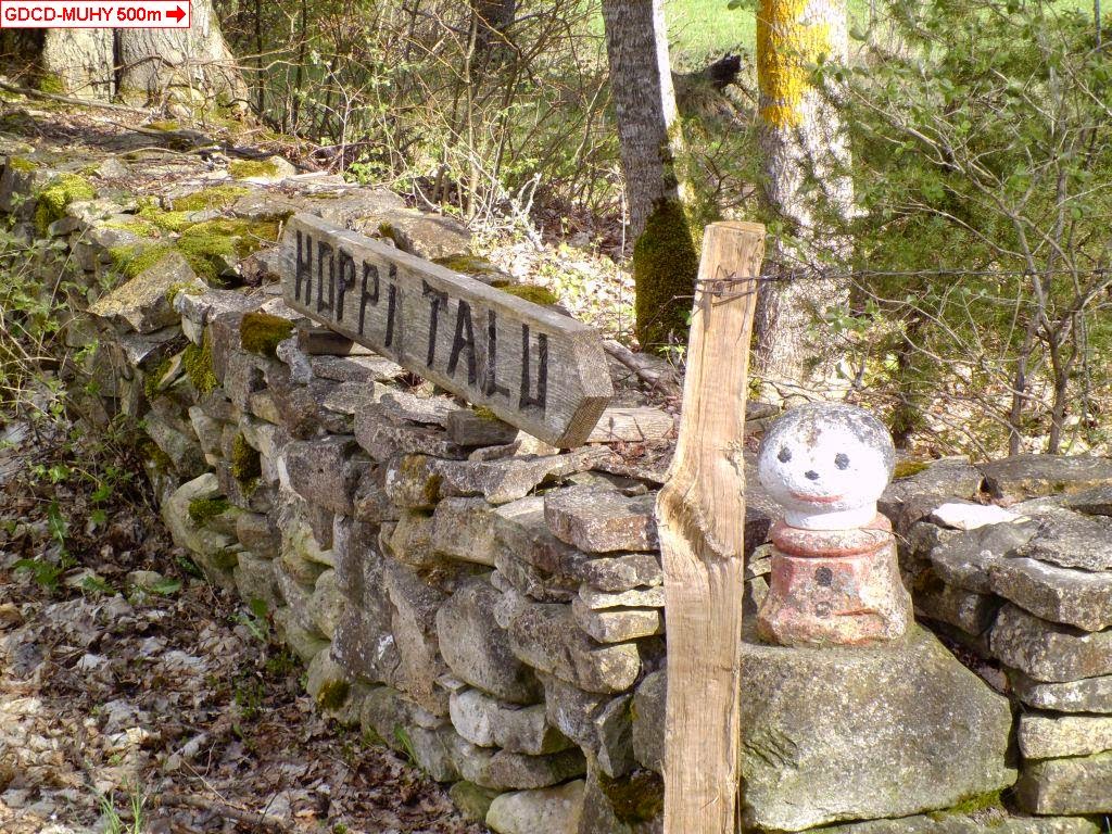
After 50min ride, the bus dropped me to 1.5km from the point. Weather was sunny, but kind of cold and windy, with occasional rain and some hail. The point was in forest and there was nothing special around it.

http://geodashing.gpsgames.org/cgi-bin/dp.pl?dp=GDCD-MUHY


"Kersna's bench" - Vahur Kersna is a well-known Estonian journalist

Ants 50m from GDCD-MUHY. Two of them were looking at me!!!

Sunday, March 16, 2014

Tatterselja 3

Geodashing Dashpoint Log
2014-03-16 20:30:42 UTC
GDCB-MOIT

Player: Haraldpoiss
Team:   FinEst Dashers

GDCB-MOIT is near Kõrkküla, Estonia.

> Date, Points, TeamPoints, Dashpoint, Country, State, Lat, Lon, Distance
2014-03-16, 3, 3, GDCB-MOIT, Estonia, , 58.2417, 22.2235, 0

Number of previous hunts by Haraldpoiss: 50

It's already 4th dashpoint that has recently fallen to near Tatterselja village. This time it was a bit northward from it. Looks like a popular place... The bus dropped me to village Hirmuste 2km from point. Name of the village can be translated as 'Scary Place' but actually there's nothing scary in it. Except maybe a burned-down farm house and a cut-through power cable that had been 'tied' back together above the road. 

There was few degrees minus outside and an alternative weather. It was occasionally sunny and occasionally snowing heavily and very windy. The road that took to the point was named as the road of "Suur Tõll", who used to be the legendary hero of Saaremaa island. Don't know why, but maybe he's known to have walked on that road then? It would have been possible to drive to 120m from the point. The point was in forest. After visiting it, I took a walk in nearby forest. It's a quiet place there. When walking back to the bus (4km) there were only 2 cars passing by me. Of which one stopped and asked if i need a lift. There are really so many kind people in the small villages of Saaremaa. Or maybe they just don't want strangers to sneak around and wanna take them away asap? Who knows. 

While there had been one more passenger in the bus when getting there, then on the way back I had the private vehicle with a driver just for me. And the driver first of all made me to knock off the snow from my boots before letting me in and then asked me to sit to the very first seat to not make all his bus dirty. And then he started talking to me and talked all 30min back to town. He told me about better life that there had been during Soviet time and that all bus traffic is fading away these days because of everybody having a car. Which seems to be true actually, at least for this line. He also told me about places where he had been traveling or been on vacation recently and his experiences, which was quite interesting. So a good reason to take bus instead of car, is to meet such nice people. On arrival he let me off in front of his home, because there were no other passengers and his home is nearer to my home than the bus station.


following the big guy...

not the house of a witch, but nest box of a bird

Roads can be dangerous. R.I.P.

Thursday, February 13, 2014

Mehama 2

Geodashing Dashpoint Log
2014-02-13 12:44:36 UTC
GDCA-MUBA

Player: Haraldpoiss
Team:   FinEst Dashers

GDCA-MUBA is near Orissaare, Estonia.

> Date, Points, TeamPoints, Dashpoint, Country, State, Lat, Lon, Distance
2014-02-13, 3, 3, GDCA-MUBA, Estonia, , 58.5264, 22.9940, 0

Number of previous hunts by Haraldpoiss: 49

It was possible to drive to 350m, from where I walked along a trail, which finally faded. The point was in forest. By chance it was only 800m GDBL-MUHY, which I visited in November 2012, during which I got stuck with car and had lot of trouble with getting out of there. Well, this time I was smarter and didn't drive that far.

http://geodashing.gpsgames.org/cgi-bin/dp.pl?dp=GDCA-MUBA


Wednesday, February 12, 2014

Mätasselja

Geodashing Dashpoint Log
2014-02-12 12:44:55 UTC
GDCA-MOAR

Player: Haraldpoiss
Team:   FinEst Dashers

GDCA-MOAR is near Kärla, Estonia.

> Date, Points, TeamPoints, Dashpoint, Country, State, Lat, Lon, Distance
2014-02-12, 3, 3, GDCA-MOAR, Estonia, , 58.3195, 22.1655, 0

Number of previous hunts by Haraldpoiss: 48

What was a dull cloudy morning in town, turned to blindingly sunny winter day in nature. As I've been lately quite busy, I didn't have time to mess with buses this time, but drove to the point instead. It was possible to drive to 300m distance after successfully passing the "Private property" sign. From there I walked over a clearance and last 50m in forest.

http://geodashing.gpsgames.org/cgi-bin/dp.pl?dp=GDCA-MOAR


Luckily the ice was carrying, despite of above-zero temperature

a nice bus-stop

Sunday, January 26, 2014

Länga

Geodashing Dashpoint Log
2014-01-26 15:14:43 UTC
GDBZ-MOCO

Player: Haraldpoiss
Team:   FinEst Dashers

GDBZ-MOCO is near Lassi, Estonia.

> Date, Points, TeamPoints, Dashpoint, Country, State, Lat, Lon, Distance
2014-01-22, 3, 3, GDBZ-MOCO, Estonia, , 58.2129, 22.1893, 0

Number of previous hunts by Haraldpoiss: 47

It was a beautiful sunny winter day with chilly -10C outside.
13:51 the bus dropped me to straight distance 3.6km from the point, where from i walked then. It took me little bit more than an hour to reach there. The point was in brush, and there was nothing especially interesting around it. After zeroing the GPS, I took a longer walk in surrounding forest. I saw a couple of black roes twice, but they ran away to between trees too fast to take a picture.
17:10 it was getting really dark and i started walking back to the bus. I reached to the stop about 45min too early, so i started walking towards home. I managed to walk 3 bus stops (3.7km) like that before the bus came.
19:39 the bus picked me up. For that time I hadn't drinken a sip of water during almost 6 hours. So i finally felt a bit thursty and took the bottle from the side-pocket of my jacket. And at least half of the water in it had frozen to ice.

http://geodashing.gpsgames.org/cgi-bin/dp.pl?dp=GDBZ-MOCO


Hit the road, Jack...

Left way or right way - choice is yours. Only that the right one is actually a ditch.

I'm not quite sure what this is, but the sign on the low concrete post says "A geodesic point under protection of Estonian Republic". Maybe I should have taken my hat off and sang the anthem?

Tuesday, January 21, 2014

Tatterselja 2

Geodashing Dashpoint Log
2013-12-31 20:57:52 UTC
GDBY-MOJI

Player: Haraldpoiss
Team:   FinEst Dashers

GDBY-MOJI is near Kõrkküla, Estonia.

> Date, Points, TeamPoints, Dashpoint, Country, State, Lat, Lon, Distance
2013-12-08, 3, 3, GDBY-MOJI, Estonia, , 58.2261, 22.2633, 0

New extreme south visit this year for Estonia: GDBY-MOJI
If this is not correct, please notify the Geodashing Webmaster

Number of previous hunts by Haraldpoiss: 46

It was a beautiful day with the very first fresh snow of this winter and slight minus temperature. Bus dropped me 3km from the destination. From there i found my way from between and through all these cottages and f&%#*ng private properties to the swamp behind them. There whole swamp was covered with the white snow that had fallen allover the plants. But underneath there was unfrozen water. Not too deep to get through with boots though. The point was in reed that was higher than my head, so nothing could be seen from there. Afterwards i took a longer walk in the swamp and nearby forest. On the way back a nice big dog started following me for i don't know what reason. And he wanted very willingly to join me on the bus back, but I didn't let him on board though.

http://geodashing.gpsgames.org/cgi-bin/dp.pl?dp=GDBY-MOJI


on the edge of the swamp

yes, i came through it

my faithful companion