2013-09-07 17:58:19 UTC
GDBV-MOIT
Player: Haraldpoiss
Team: FinEst Dashers
GDBV-MOIT is near Kõrkküla, Estonia.
> Date, Points, TeamPoints, Dashpoint, Country, State, Lat, Lon, Distance
2013-09-07, 3, 3, GDBV-MOIT, Estonia, , 58.2272, 22.2532, 0
New extreme south visit this year for Estonia: GDBV-MOIT
New extreme west visit this year for Estonia: GDBV-MOIT
If this is not correct, please notify the Geodashing Webmaster
Number of previous hunts by Haraldpoiss: 43
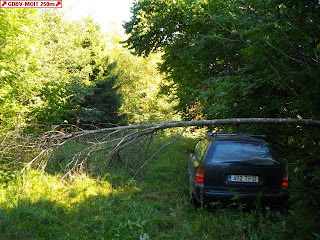
It was possible to drive to 130m, but it was a small road through the woods and so rarely used that occasionally the grass on it was actually higher then my head while I was sitting in car. Finally a fallen tree over it made me stop. Then I walked, but it was not so easy either, as there were a lot of unpassable muddy pools there and I had to find my way around these. The point was in reed, plants higher then my head while I was standing there. Afterwards I took a 3h walk in nerby swamp, reed, forest and meadows. The weather was warm and sunny. In the woods I saw a wild boar from very close-up. A tractor was cutting down hey on a meadow, but this hey was actually very mixed up with reed.
http://geodashing.gpsgames.org/cgi-bin/dp.pl?dp=GDBV-MOIT
a low passage...
a strange mushroom on a tree, 1.3km from GDBV-MOIT
a wild boar hunting tower on a meadow


